Monday, September 28, 2020

Helena

Judy. When we found out that we couldn’t stay in Missoula for a second month, we began a search for where we COULD stay. We’d visited several towns on the way to Missoula, but none really captured our attention. So one day we drove to Helena--and decided to come here. 

 For one thing, it’s charming. The neighborhood we were looking at is beautiful and, although hilly, walkable. A block from the Airbnb are several paths up Mt. Helena.
  

 Last Chance Gulch, the downtown area, is within walking distance, and has both a Bridge Pizza and Big Dipper Ice Cream, both of which we enjoyed in Missoula. The day we left Spokane, the smoke followed us almost as far as Missoula, and by the time we arrived in Helena, was gone. Hurrah! Hiking on the horizon! 

 But two days later, the smoke had caught up with us, where it sat for the next week. Time to look for some alternatives. The first day, we walked down to Last Chance Gulch, a mostly pedestrian mall with shops, restaurants, and craft breweries. (Montana supposedly has more craft breweries than any other state). Ted bought a beer at Ten Mile Brewery and sat on a bench sipping it while I explored. There’s lots of artwork along the mall, and the buildings have mostly been saved and restored. As you look up the hill to your left, you can see the magnificent St. Helena Catholic Cathedral, modeled after one in Austria. Many houses in the area are Victorian and magnificent—this town meant money! 
Gold money!
        
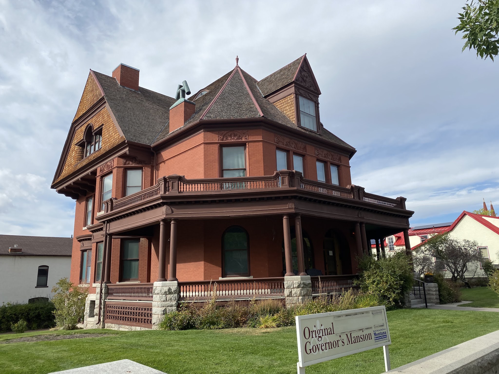
Old Governor's Mansion


 Of course it did. In the 1860’s, gold was discovered by the “Four “Georgians” (search that phrase on Wikipedia for the full story), and the town of Last Chance took shape, although the name was changed in a few months to Helena—Last Chance being far too crass a name. By 1888, it was the richest city in the world, and the homes show it. Helena, which is the state capitol, is fairly small: In the 2010 census, it had almost 29,000 residents, as opposed to Missoula’s approximately 74,500. Walking up Mt. Helena, you can see the entire township laid out before you. It’s a comfortable place to be, and a great hub from which to explore. So we did, trying to work around the good, moderate, and unhealthy days due to the smoke. 
From Mt. Helena on a smoky day

   
From Mr. Helena on a clear day


 Ted already told you about Gates of the Mountains, an experience we’ll not soon forget. Another day we drove north to Great Falls, which was a disappointment, and on up to Ft. Benton, which we enjoyed. While Stevensville claims to be the first settlement in Montana, Ft. Benton calls itself the first town, since it’s on the Missouri River, and was the port from which goods were taken along a myriad of trails to other parts of the territory. It’s also another “Lewis and Clark” stop. We ducked into a museum and saw Chief Joseph’s Winchester he used for his surrender. 

On a day when the air was moderate, we hiked the couple of miles up Mt. Helena. It’s a short distance, but there were no switchbacks, and the path straight up was tough! Still, it was great to see what view we could, with smoke still lingering. A week later, after it cleared, we climbed partway up—the difference was stunning. On Saturday it rained and we visited the Montana Historical Society Museum. What a delightful surprise. Cost is a minimal $5, and we spent hours exploring the state’s history from the earliest native peoples to present day. “Whiskey’s for drinking; water’s for fighting”—a story told all over the West. 

 Across the hall is a gallery of Charles Russell’s art. I knew of his Western works, but some of the best works were of his watercolors painted on letters to friends. 
Russell Christmas Card


 Of course, the best part is meeting people. Remember our dear friends Carolyn and Doug, who have lent us their house on many occasions? Carolyn contacted their nephew Stephen and his wife Allison who live here, and they met us in a park on a 48-degree morning with coffee and bagels and wonderful conversation about their lives here. Both work for Montana Fish, Wildlife and Parks, Allison with birds, Stephen, with fish and water. That’s where I learned how complicated water rights are. We could have talked to them all day, had they not had to go to work. Those are some folks I truly hope to meet again. 


Allison and Stephen, two of the coolest folks you'll meet


 Helena is just over the MacDonald Pass, where the Continental Divide runs. There is an unfinished trail, Mexico to Canada, called the Continental Divide Trail, and we decided to hike part of it. It was beautiful, although marred by trees killed by the Pine Bark Beetle, fallen, as a friend put it, like pickup sticks. The trail is easy, running across a ridge, but enough trees were still growing to keep us from any views. 
Beetle kill on Continental Divide Trail


Our last hike was to Refrigerator Canyon. It was an hour’s drive there, much of it on gravel roads through “towns” like Jimtown, Nelson, and York (which hosts a bar). The trailhead was hidden between two limestone mountains, and you had to walk up the stream through the notch between them. Once you came out the other side, you felt as though you had entered a secret garden! The trail took you gradually up switchbacks till you reached the top of the mountain with heart-stopping views down into the valley. We met no one on the trail until we were leaving through the notch. It’s one of our favorite hikes of all time. 


Entrance to Refrigerator Canyon

View from the top


 So—if we came back, where would we stay, Missoula or Helena? They are as different as apples and peaches. For day-to-day life and walkability to groceries, farmer’s markets, and quick hikes, Missoula, hands down. For history and rugged canyons, Helena. For a month, probably Missoula. For a couple of weeks, Helena. Good to know that both are here!

Saturday, September 26, 2020

Buffalo Jump

Ted. We have all seen the paintings of Indians hunting buffalo on horseback. It is beautiful and a bit frightening. If you have ever been close to one of these shaggy beasts, it is hard to imagine riding a horse alongside one at a full gallop – let alone trying to stab it with a lance. So how did Indians take advantage of this wonderful source of food and clothing if they didn’t have horses? They used buffalo jumps. 

Judy and I visited the First Peoples Buffalo Jump State Park in Ulm, Montana to learn about this practice. To describe what would typically take place here, I turn once more to the journal of Meriwether Lewis from May of 1805: 

“today we passed on the Stard. side the remains of a vast many mangled carcases of Buffalow which had been driven over a precipice of 120 feet by the Indians and perished; the water appeared to have washed away a part of this immence pile of slaughter and still their remained the fragments of at least a hundred carcases they created a most horrid stench. in this manner the Indians of the Missouri distroy vast herds of buffaloe at a stroke; for this purpose one of the most active and fleet young men is scelected and 〈being〉 disguised in a robe of buffaloe skin, having also the skin of the buffaloe's head with the years and horns fastened on his head in form of a cap, thus caparisoned he places himself at a convenient distance between a herd of buffaloe and a precipice proper for the purpose, which happens in many places on this river for miles together; the other indians now surround the herd on the back and flanks and at a signal agreed on all shew themselves at the same time moving forward towards the buffaloe; the disguised indian or decoy has taken care to place himself sufficiently nigh the buffaloe to be noticed by them when they take to flight and runing before them they follow him in full speede to the precepice, the cattle behind driving those in front over and seeing them go do not look or hesitate about following untill the whole are precipitated down the precepice forming one common mass of dead an mangled carcases; the 〈Indian〉 decoy in the mean time has taken care to secure himself in some cranney or crivice of the clift which he had previously prepared for that purpose. the part of the decoy I am informed is extreamly dangerous, if they are not very fleet runers the buffaloe tread them under foot and crush them to death, and sometimes drive them over the precepice also, where they perish in common with the buffaloe.” 

To paint a better picture of the scene at the base of the cliff, I should add that the Blackfeet Indians refer to a place like this as a “pis’kun” which roughly translates as “deep kettle of blood.” This particular piskun, or jump is thought to be the largest in the world, which is hard to say because there were probably thousands dating back many millennia. In fact, this would have been my choice for killing woolly mammoths back in the day. I’ll conclude with a few photos from our visit.

Start of 1.5 mile walk to the cliff


Prairie Rattlesnake


From the top there's no sign of a dropoff


The 75' fall would maim the animals, not kill them 


Where the village gathered for the slaughter

Wednesday, September 23, 2020

Gates of the Mountains

Ted. On July 19, 1805 the Lewis & Clark expedition entered a spectacular stretch of the Missouri River about 25 miles north of present day Helena, where we currently reside. At days end, Meriwether Lewis made the following entry in his journal, “...those rocks put in close to the river on both sides, are perpendicular and about 1200 feet high, this place has so singular an appearance that I call it the gates of the rocky mountains.” 


This part of the Helena-Lewis and Clark National Forest is now called the Gates of the Mountains Wilderness area and is still only accessible by boat. For the last 125 years, tour boats have taken visitors along this famous stretch of river. On a day that we deemed too smoky to hike, Judy and I decided to take the 2-hour tour. Our boat had a capacity of around 100 people, which allowed the 35 or so passengers to have plenty of social distancing. I have to admit that riding in a boat is certainly easier than hiking through a canyon. 

Our guide, Tim, began by identifying several species of waterfowl including the first loon that we had ever seen. A hush came over the crowd as we approached those formidable cliffs. 


Much of the rock in the Helena area is ancient basalt but the cliffs in this canyon are limestone; much younger, lighter colored and full of fossils.  While we couldn't see those from our boat, we did see some pictographs on one cliff. Scientists believe that people painted the figures using red ochre about 1,500 years ago. We also saw a fair amount of wildlife along the way.

One of 3 bald eagles we spotted


Young bighorn sheep at a salt lick


Last year, while touring the Missoula Smokejumper Visitor Center, we learned about of the Mann Gulch Fire. In 1949, 15 smokejumpers parachuted into Mann Gulch to put out a fire but only 3 of them made it out alive. The tragedy was the basis for Norman Maclean’s book, Young Men and Fire as well as the 1952 film Red Skies of Montana. Well, unbeknownst to us, Mann Gulch is in Gates of the Mountains and we passed right by the spot where those brave young men lost their lives. 


With so much history and beauty in a small area this proved to be another gem of the Treasure State.


Sunday, September 13, 2020

West to the Columbia

Ted. After a month in Missoula, it was time to follow in the footsteps of the Lewis & Clark expedition and wander over the Bitterroot Mountains, tumble down onto the plains and make our way to the mighty Columbia River, the path to the Pacific Ocean. We followed their route over Lolo Pass and stopped in Orofino, Idaho where the explorers constructed dugout canoes from massive Ponderosa pines. From there we left their path and drove north, via Moscow, Idaho and Pullman, Washington to Spokane, WA where we checked into an Airbnb that would be home for 10 days.


Dugout at Clearwater Historical Museum


Spokane served as a good base for us to explore an area of the Northwest we did not know. One day we took a road trip to nearby Idaho, first visiting beautiful Coeur D’Alene, on the lake of the same name. We then drove north to Sandpoint, following the shore of Lake Pend Oreille to the town of Clark Fork where the Clark Fork River (last seen in Missoula) ends it journey in the lake. 


Lake Pend Oreille


Floating Restaurant, Hope, ID

On another day trip we drove west to visit old Fort Spokane, built where the Spokane River empties into the Columbia River to protect the Indians living in two reservations across the rivers.  


Remains at Ft Spokane


Spokane River (L) entering Columbia


A tour of downtown Spokane focused on Riverfront Park, site of the 1974 World’s Fair (who knew?). We also found time for a hike along Iller Creek, just outside of town.


Upper Spokane Falls


Clock tower

Fun slide


Spokane Valley from Iller Creek trail


For the second half of our time in Spokane we were joined by our good friends Terry & Sue. Natives of Washington, we enjoyed having a rendezvous with folks who really know the area. We also had a great time relaxing, visiting and enjoying local salmon and wine.


Terry in  DC3 at flight museum


Sue & Terry & salmon & wine

As you may have read, California, Oregon and Washington have been the scene of horrific wild fires in September. For nine days we had escaped any of the damage, or lingering smoke but our last day proved to be pretty bad. Overnight the air grew thick with smoke – even waking me up in the night. So, when we packed our bags to drive back to Montana, we were sad to leave our friends but glad to get out of the smoke.


Time to go!


Tuesday, September 1, 2020

Sculpture in the Wild

 Judy.  If one of you is the person who suggested we visit the Blackfoot Pathways Sculpture in the Wild, we want to send you a huge THANK YOU! 


On a gorgeous just-starting-to-turn cool Sunday morning, we headed up the Blackfoot Valley to Lincoln, where we were told there is an outdoor sculpture park. Ted and I, as you have surmised, love museums, but right now are a little picky about being inside, so the opportunity to see a collection of sculpture in an outdoor setting sounded perfect.


The drive up any of the valleys surrounding Missoula is breathtakingly beautiful, and Blackfoot was no different, with vast ranches surrounded by majestic mountains, and sparkling rivers running beside the highway. Once you reach Lincoln, though, the ponderosa pines take over. The little town reminded me of Talkeetna, Alaska.


Just out of Lincoln, a turn to the left takes you into the park. We were surprised to see the number of cars in the lot, virtually all of them with Montana license plates. Several families were there, toddlers to grandparents, dashing down the many paths to various artworks.


With so many visitors, we were concerned about social distancing, but the park is vast, with multiple trails to the site-specific works. Some, like the Montana Memory, which utilized an actual Tee Pee Burner that had been part of a sawmill where leftovers were burned, were historical. Others celebrated the topography of the land surrounding it.  Sculptors from all over the world came to the park, then submitted their designs, which were often constructed with the help of locals. For more information, and to see more sculptures, you can go to www.sculptureinthewild.com.  


As Ted noted in his last post, a picture is worth 1,000 words, so I’ll leave you with these: